The Giant Hairball Intersection is up for review & reconstruction. Here is my take:


First principles first:
-Streets are ‘readable.’ Urban neighborhood streets should look & feel and ‘read’ like urban neighborhood streets, not on-ramps to expressways. Both Willy and E. Wilson look like on-ramps as they go off from the hairball intersection. Thus, they are inviting for through-traffic rather than neighborhood business destination traffic. This problem remains with the Design Professionals plan.
-Road capacity is defined at intersections. Left turns at intersections bollix everything up in such a constrained area, and for the benefit of very, very few people.
-Parks should be for people, not machinery. Eliminate the boat ramp and all parking entirely. A Boat ramp at this location is a legacy from when Madison was much smaller, and John NoLane was much smaller (i.e., park was bigger), and boat motors were much smaller, boats a lot slower. Now people towing boats can much more easily access much larger and more appropriate boat landings anywhere on the Yahara Chain of Lakes and arrive anywhere on those lakes within minutes by boat. Faster than a car towing a boat even (no stop lights on the lake!). Today, we have significant population growth in the immediate area. Huge apartment towers are going up constantly. These people access the lakes by foot & bike. Park space should prioritize them above the motor people. The city has changed, park use has changed. Time to acknowledge this and adapt appropriately.
-Scale is of paramount importance, for this intersection and its environs, for pedestrian & bicyclist safety in particular. The tighter the lanes, the narrower the total road width and the smaller the intersections are, the better for people on foot & on bike.
-LOS = Level of Service in Traffic Engineering jargon. It is usually used to justify gigantic roads through neighborhoods. Traffic engineers never apply this schema to pedestrian and cycling traffic. This is a first. Nobody wants an ‘F’, right?
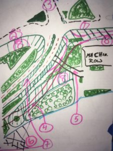
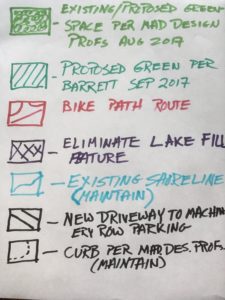
Specifics (#s as coded on Diagram for People):
1 – Willy St. returned to it’s typical width and configuration as found at Paterson or Baldwin. On-street parking (no rush hour restrictions) the entire length, up to the intersection itself. All dedicated right turns–especially flying rights–are eliminated. It is inviting only insofar as one might have actual *business* to conduct on the street. Definitely not attractive as a commuter route.
2 – Similar to above, E. Wilson returned to a neighborhood-scaled business district street. On-street parking. All dedicated flying rights eliminated.
3 – Blair St remains similar to current configuration with these improvements for efficiency without widening:
-No left turns for its entire length from any direction.
-Northeast/outbound onto E. Wash has one single *dedicated* right turn lane becoming a dedicated lane onto E Wash that is protected from other E-bound traffic. This can be done without any widening. This allows a constant green arrow, except when triggered by a pedestrian. This will keep Blair flowing its entire length, taking pressure off of the hairball intersection (it routinely backs up from E. Wash all the way to the Hairball during rush hour).
-Do “no left turn” signs work? Well, from my experience, they do. The no-rights in the Atwood hood (Division & Atwood; Dunning & Atwood) are working wonderfully to protect cyclists & peds. I have yet to see anyone violate them in the years they’ve been there. And I use those intersections daily, often multiple times a day. They were the site of many a crash, before the no-rights.
-These measures will make Blair->E. Wash so efficient that there will no longer be a need for all the traffic onto Willy St.
1, 2 & 3 – Scramble cycle: Entire intersection goes green for pedestrians, bikes, rollerblades *only*, all directions, including diagonally across the intersection. All stop for all motor vehicles, no right on red. It is time to recognize that this is a site of intense pedestrian/bike density (has anyone noticed the many towering apartments that are going up like mushrooms within a block of this intersection?). It is time to bring ped/bike LOS up from its current F status to LOS A.
4 – Bike path ever-so-subtly swerves away from JN. No sharp turns. A) It makes for a more pleasant ride, B) it brings the bike path away from JN enough to allow right turning cars to/from the new driveway (Point 5 below) to have some stack room after turning right off of JN, or as they attempt to re-enter JN. Bike path should be raised in relation to the driveway to slow traffic using the driveway.
5 – New driveway accessing parking behind Machinery Row. (See 4. above). Must go over the significantly tabled bike path after yielding to bike path cross traffic. Driveway is very narrow–+/- 18′. Stack room for 2 cars between JN and bike path.
6 – Eliminate lake fill marina feature. Even using a world-famous architect’s cachet should not allow for this travesty. Put the feature over the highway itself, if need be.
7 – Eliminate the left from SW-bound (toward Monona Terr) onto Law Park boat ramp parking. It is a disaster in the making for everyone involved. Plus, the legacy boat ramp is eliminated (as explained above). Permit U-turns at the Monona Terrace stop light for “jug handle”* access back to Machinery Row. (*Oh yes, this is a term of art in the traffic engineering world; there is a “jug handle” way out on Mineral Pt Rd, near the westside Menards/Target area.) This will require traffic waiting to exit the ramp and enter JN to wait for a specific green arrow, no right on red (to avoid crashes with U-turners on JN).
8 – Significantly expanded greenspace by eliminating the anachronistic boat ramp, and returning Williamson St and E. Wilson St to neighborhood scale.
In the face of a cooking climate, I’m not interested in nibbling around the edges. It is time to stop the denialism rampant in the pro-car power structure (it’s across the spectrum; it ain’t just a certain president) and do what needs to be done to prioritize sustainable neighborhoods and sustainable transportation.
-Mike
*John Nolen was given the moniker, John Nolane by the inimitable Tim Wong during the mega-battles over the bike lane closure during the construction of what he called “The Enemy Citadel,” a.k.a., the Monona Terrace back in the early-90s. I’ll generally refer to John Nolen as NoLane as a perma-tribute to Tim.